












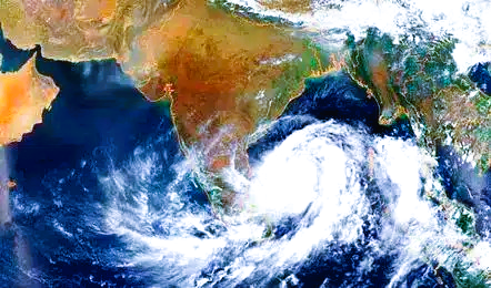
Bay of Bengal Weather Alert: New System May Intensify Into Depression
Bhubaneswar: A fresh weather system is likely to take shape over the Bay of Bengal later this week, with the India Meteorological Department (IMD) indicating the formation of a low-pressure area around October 23.
According to meteorological projections, an upper-air cyclonic circulation currently active over the Gulf of Thailand, Thailand, and Myanmar is expected to move into the North Andaman Sea before triggering the development of the system.
The anticipated low-pressure area is expected to form over the southeast and adjoining east-central Bay of Bengal. Meteorologists suggest that the system may gradually intensify while moving northwestward over the central Bay of Bengal.
It could strengthen into a well-marked low-pressure area and potentially develop further into a depression depending on prevailing atmospheric and oceanic conditions.
While the exact intensity, trajectory, and potential landfall location remain uncertain at this stage, weather agencies are closely monitoring its evolution. More clarity is expected once the low-pressure area formally develops over the Bay waters.
The emerging weather system has attracted attention in eastern coastal states, including Odisha, West Bengal, and Andhra Pradesh, due to the Bay of Bengal’s history of generating significant weather disturbances during this period of the year.
Authorities have advised fishermen and maritime operators in the Andaman Sea and Bay of Bengal to keep track of official weather bulletins and follow safety advisories issued by meteorological agencies.
Residents along coastal regions are also encouraged to stay informed through official updates as the situation develops in the coming days.