


ISRO gearing up for July 30 INDO-US NISAR satellite launch starting launch rehearsal
By Venkatachari Jagannathan
Chennai, July 28 (UNI) The Indian Space Research Organisation (ISRO) is gearing up for the July 30 evening launch of the Indo-US Earth observation satellite — NASA-ISRO Synthetic Aperture Radar (NISAR) — and has begun launch rehearsals, an official said.
An ISRO official, who did not wish to be named, said that launch rehearsals are currently underway, although the formal countdown is yet to begin.
During the launch rehearsal, ISRO checks out all the rocket systems, stimulates the launch sequence including the fuel loading, countdown and others that includes aborting the launch.
India’s Geosynchronous Satellite Launch Vehicle-F16 (GSLV-F16) will lift off at 5.40 pm from the rocket port in Sriharikota, Andhra Pradesh.
Approximately 19 minutes after liftoff, the 420-tonne GSLV-F16 — an expendable launch vehicle — will deploy the NISAR satellite, which weighs around 2,400 kg, into a 747-km Sun-synchronous orbit (SSO) with an inclination of 98.4 degrees, according to ISRO.
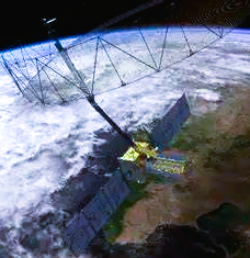
Built at a cost of about USD1.5 billion, NISAR’s mission life will be five years and its mission is to observe earth in unprecedented detail.
A retired ISRO chairman clarified that NISAR is intended exclusively for Earth observation and not for strategic or military purposes, despite its sophisticated Synthetic Aperture Radar (SAR) capability, which allows it to image the Earth through clouds.
A retired chief of ISRO said NISAR is only for earth observation and not for strategic purposes though it has SAR that can look through the clouds.
The Indian Space Agency said, NISAR is a unique earth observation satellite and the first satellite to observe the earth with a dual frequency Synthetic Aperture Radar (NASA’s L-band and ISRO’s S-band).
The satellite will observe earth with a swath of 242 km and high spatial resolution, using SweepSAR technology for the first time.
According to ISRO, the satellite will scan the entire globe and provide all weather, day and night data at 12-day intervals and enable a wide range of applications.
NISAR can detect even small changes in the Earth’s surface such as ground deformation, ice sheet movement and vegetation dynamics.
Further applications include sea ice classification, ship detection, shoreline monitoring, storm characterization, changes in soil moisture, mapping and monitoring of surface water resources and disaster response, the Indian space agency added.
The data gathered will assist in tasks as infrastructure monitoring, disaster response, biomass assessment, and agricultural management.
ISRO identified science and applications that were complementary to the primary mission objectives: agricultural monitoring and characterization, landslide studies, Himalayan glacier studies, soil moisture, coastal processes, coastal winds, and monitoring hazards.
The NISAR mission is the result of over a decade of close technical collaboration between ISRO and NASA’s Jet Propulsion Laboratory (JPL).
NISAR will be the first Earth-observing satellite with two kinds of radar — an L-band system with a 10-inch (25-centimeter) wavelength and an S-band system with a 4-inch (10-centimeter) wavelength.
The NISAR carries a 12m wide deployable mesh reflector mounted onto a deployable 9m boom developed by NASA’s JPL which shall be used by both-JPL-NASA developed L-Band SAR payload system and ISRO developed S-Band SAR payload.
Whether microwaves reflect or penetrate an object depends on their wavelength. Shorter wavelengths are more sensitive to smaller objects such as leaves and rough surfaces, whereas longer wavelengths are more reactive with larger structures like boulders and tree trunks.
So NISAR’s two radar signals will react differently to some features on Earth’s surface. By taking advantage of what each signal is or isn’t sensitive to, researchers can study a broader range of features than they could with either radar on its own, observing the same features with different wavelengths.
After the successful in-orbit checkout of the satellite, the science operations phase will start and extend for three years and contain all data collection required to achieve the L1 science objectives.
During this phase, the science orbit will be maintained via regular maneuvers, scheduled to avoid or minimize conflicts with science observations. Extensive calibration and validation activities will take place throughout the first five months, with yearly updates of 1-month duration.
The data acquired through S-band and L-band SAR from a single platform will help the scientists to understand the changes happening to Planet Earth.
The launch of the NISAR satellite was initially planned for 2022 or early 2023, but faced multiple delays.
In 2025, the launch was expected to occur in June, but was postponed again.
ISRO and NASA first formalized their collaboration on NISAR through an equal partnership agreement signed on September 30, 2014.